Dataset M179-1.202112.A
Date of Receipt
Data Type
Data Amount
Surveyed Kilometres
Sea Area
Data Format
Data Processing
Sound Velocity Correction
| Fahrtleiter Chief Scientist |
Dr. Jochen Wollschläger | ||||||
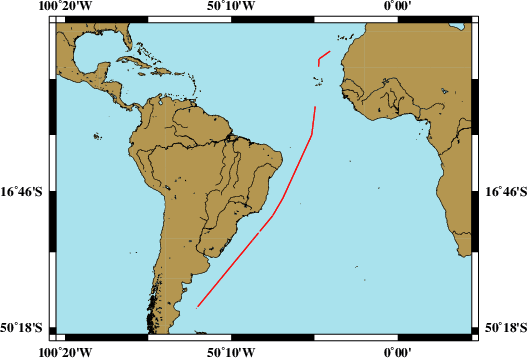
| Vermessungszeitraum Survey Period |
2021/12/21 - 2022/01/12 | ||||||
| Auslaufhafen Port of Departure |
Las Palmas, Canary Islands / Spain | ||||||
| Einlaufhafen Port of Arrival |
Punta Arenas / Chile | ||||||
| Institution | ICBM | ||||||
| Positionierungssystem Positioning System |
|
||||||
| Horizontales Datum Horizontal Datum |
WGS 84 | ||||||
| Tiefenbestimmungssystem Bathymetric System |
SIMRAD EM122 | ||||||
| Vertikales Datum Vertical Datum |
Sea Level. | ||||||
| Datendistribution Dataset Distribution |
|
||||||
| Zitat Citation |
Bathymetriedaten der Reise M179/1 des Forschungsschiffes Meteor. Herausgeber: ICBM - Institut für Chemie und Biologie des Meeres, Wilmhelmshaven 2021 | ||||||
| DOD-Referenz DOD-Reference |
20220001 |
| Datensatz M179-1.202112.A Dataset M179-1.202112.A |
Eingangsdatum: 2022/02/21 Date of Receipt |
||
|---|---|---|---|
| Datenart Data Type |
Datenmenge Data Amount |
Lotungskilometer Surveyed Kilometres |
Seegebiet Sea Area |
| Multibeam Data, Binary | 14015 MByte | 7500 | |
| Datenformat Data Format |
Datenprozessierung Data Processing |
Schallgeschwindigkeitskorrektur Sound Velocity Correction |
|
| SIMRAD EM122 (ALL) | No filters are used. | Sound velocity from CTD deployments and, or SVP. Sound velocity at the keel provided by the given sound velocity profile or, if possible, the vessel mounted SV-probe. | |