Dataset SO266-1.201810.A
Date of Receipt
Data Type
Data Amount
Surveyed Kilometres
Sea Area
Data Format
Data Processing
Sound Velocity Correction
| Fahrtleiter Chief Scientist |
Prof. Dr. Gerhard Bohrmann | ||||||
| Vermessungszeitraum Survey Period |
2018/10/15 - 2018/11/18 | ||||||
| Auslaufhafen Port of Departure |
Kaohsiung / Taiwan | ||||||
| Einlaufhafen Port of Arrival |
Kaohsiung / Taiwan | ||||||
| Institution | MARUM | ||||||
| Positionierungssystem Positioning System |
|
||||||
| Horizontales Datum Horizontal Datum |
WGS 84 | ||||||
| Tiefenbestimmungssystem Bathymetric System |
SIMRAD EM122, SIMRAD EM710, ATLAS PARASOUND | ||||||
| Vertikales Datum Vertical Datum |
Sea Level. | ||||||
| Datendistribution Dataset Distribution |
|
||||||
| Zitat Citation |
Bathymetriedaten der Reise SO 266/1 des Forschungsschiffes Sonne. Herausgeber: MARUM | Zentrum für Marine Umweltwissenschaften, Bremen 2018 |
||||||
| DOD-Referenz DOD-Reference |
20180051 |
| Datensatz SO266-1.201810.A Dataset SO266-1.201810.A |
Eingangsdatum: 2019/02/13 Date of Receipt |
||
|---|---|---|---|
| Datenart Data Type |
Datenmenge Data Amount |
Lotungskilometer Surveyed Kilometres |
Seegebiet Sea Area |
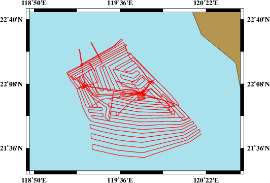
| Multibeam Data, Binary | 98899 MByte | 4000 | |
| Datenformat Data Format |
Datenprozessierung Data Processing |
Schallgeschwindigkeitskorrektur Sound Velocity Correction |
|
| SIMRAD EM122 (ALL & WCD) | Postprocessing software MB-System, position and depth processing. QPS FM Midwater for Water Column Data processing. | Several SVPs/CTDs have been taken during the cruise and applied directly or during post-processing. | |
| Datensatz SO266-1.201810.B Dataset SO266-1.201810.B |
Eingangsdatum: 2019/02/13 Date of Receipt |
||
|---|---|---|---|
| Datenart Data Type |
Datenmenge Data Amount |
Lotungskilometer Surveyed Kilometres |
Seegebiet Sea Area |
| Multibeam Data, Binary | 8738 MByte | 350 | 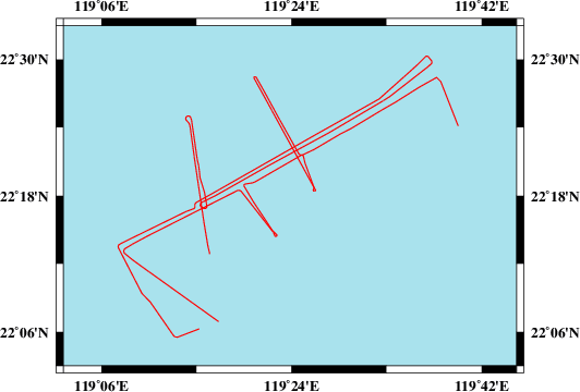 |
| Datenformat Data Format |
Datenprozessierung Data Processing |
Schallgeschwindigkeitskorrektur Sound Velocity Correction |
|
| SIMRAD EM710 (ALL & WCD) | Postprocessing software MB-System, position and depth processing. QPS FM Midwater for Water Column Data processing. | Several SVPs/CTDs have been taken during the cruise and applied directly or during post-processing. | |
| Datensatz SO266-1.201810.C Dataset SO266-1.201810.C |
Eingangsdatum: 2019/02/13 Date of Receipt |
||
|---|---|---|---|
| Datenart Data Type |
Datenmenge Data Amount |
Lotungskilometer Surveyed Kilometres |
Seegebiet Sea Area |
| Sediment Acoustic Data, Binary | 56240 MByte (ASD.ACF-PHF) 103687 MByte (ASD.ACF-SLF) 4504 MByte (PS3-PHF) 24540 MByte (PS3-SLF) 34437 MByte (SEGY-PHF) 48928 MByte (SEGY-SLF) |
- | 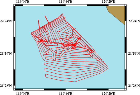 |
| Datenformat Data Format |
Datenprozessierung Data Processing |
Schallgeschwindigkeitskorrektur Sound Velocity Correction |
|
| ATLAS PARASOUND (ASD.ACF & PS3 & SEGY) | No information. | No information. | |