Dataset SO262.201804.A
Date of Receipt
Data Type
Data Amount
Surveyed Kilometres
Sea Area
Data Format
Data Processing
Sound Velocity Correction
| Fahrtleiter Chief Scientist |
Dr. Carsten Rühlemann | ||||||
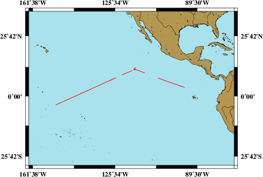
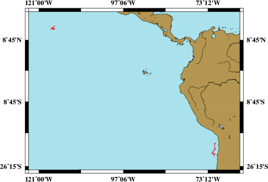
| Vermessungszeitraum Survey Period |
2018/04/06 - 2018/05/29 | ||||||
| Auslaufhafen Port of Departure |
Guayaquil / Ecuador | ||||||
| Einlaufhafen Port of Arrival |
Suva / Fiji | ||||||
| Institution | BGR | ||||||
| Positionierungssystem Positioning System |
|
||||||
| Horizontales Datum Horizontal Datum |
WGS 84 | ||||||
| Tiefenbestimmungssystem Bathymetric System |
SIMRAD EM122, ATLAS PARASOUND | ||||||
| Vertikales Datum Vertical Datum |
Sea Level. | ||||||
| Datendistribution Dataset Distribution |
|
||||||
| Zitat Citation |
Bathymetriedaten der Reise SO262 des Forschungsschiffes Sonne. Herausgeber: Bundesanstalt für Geowissenschaften und Rohstoffe, Hannover 2018 |
||||||
| DOD-Referenz DOD-Reference |
20180047 |
| Datensatz SO262.201804.A Dataset SO262.201804.A |
Eingangsdatum: 2018/07/02 Date of Receipt |
||
|---|---|---|---|
| Datenart Data Type |
Datenmenge Data Amount |
Lotungskilometer Surveyed Kilometres |
Seegebiet Sea Area |
| Multibeam Data, Binary | 23440 MByte | 5900 | |
| Datenformat Data Format |
Datenprozessierung Data Processing |
Schallgeschwindigkeitskorrektur Sound Velocity Correction |
|
| SIMRAD EM122 (ALL & WCD) | Postprocessing software CARIS HIPS, position and depth processing. | A function sound velocity profile is used during the survey, check is used permanently during the survey. | |
| Datensatz SO262.201804.B Dataset SO262.201804.B |
Eingangsdatum: 2018/07/02 Date of Receipt |
||
|---|---|---|---|
| Datenart Data Type |
Datenmenge Data Amount |
Lotungskilometer Surveyed Kilometres |
Seegebiet Sea Area |
| Sediment Acoustic Data, Binary | 36685 MByte (ASD.ACF-PHF) 69097 MByte (ASD.ACF-SLF) 291 MByte (PS3-PHF) 387 MByte (PS3-SLF) 567 MByte (SEGY-PHF) 763 MByte (SEGY-SLF) |
- |  |
| Datenformat Data Format |
Datenprozessierung Data Processing |
Schallgeschwindigkeitskorrektur Sound Velocity Correction |
|
| ATLAS PARASOUND (ASD.ACF & PS3 & SEGY) | No information. | No information. | |