Dataset SO286.202111.A
Date of Receipt
Data Type
Data Amount
Surveyed Kilometres
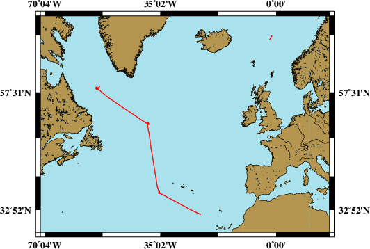
Sea Area
Data Format
Data Processing
Sound Velocity Correction
| Fahrtleiter Chief Scientist |
Dr. Saskia Brix | ||||||
| Vermessungszeitraum Survey Period |
2021/11/05 - 2021/12/09 | ||||||
| Auslaufhafen Port of Departure |
Emden / Germany | ||||||
| Einlaufhafen Port of Arrival |
Las Palmas, Canary Islands / Spain | ||||||
| Institution | DZMB | ||||||
| Positionierungssystem Positioning System |
|
||||||
| Horizontales Datum Horizontal Datum |
WGS 84 | ||||||
| Tiefenbestimmungssystem Bathymetric System |
SIMRAD EM122 | ||||||
| Vertikales Datum Vertical Datum |
Sea Level. | ||||||
| Datendistribution Dataset Distribution |
|
||||||
| Zitat Citation |
Bathymetriedaten der Reise SO286 des Forschungsschiffes Sonne. Herausgeber: Senckenberg am Meer, Deutsches Zentrum für Marine Biodiversitätsforschung, Hamburg 2021 |
||||||
| DOD-Referenz DOD-Reference |
20210026 |
| Datensatz SO286.202111.A Dataset SO286.202111.A |
Eingangsdatum: 2022/01/07 Date of Receipt |
||
|---|---|---|---|
| Datenart Data Type |
Datenmenge Data Amount |
Lotungskilometer Surveyed Kilometres |
Seegebiet Sea Area |
| Multibeam Data, Binary | 10250 MByte | 5100 | |
| Datenformat Data Format |
Datenprozessierung Data Processing |
Schallgeschwindigkeitskorrektur Sound Velocity Correction |
|
| SIMRAD EM122 (ALL) | Post-processing software Qimera v2.0.3 | A function sound velocity profile is used during the survey. Check is used permanently used during the survey. Seabird CTD sound velocity profile is used for beam correction before a survey. During transit the sound speed manager tool is used. It ingests regularly updated SV profiles into SIS automatically taken from a world data base. | |