Dataset M175.202106.A
Date of Receipt
Data Type
Data Amount
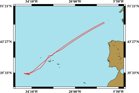
Surveyed Kilometres
Sea Area
Data Format
Data Processing
Sound Velocity Correction
| Fahrtleiter Chief Scientist |
Dr. Thor H. Hansteen | ||||||
| Vermessungszeitraum Survey Period |
2021/06/02 - 2021/06/28 | ||||||
| Auslaufhafen Port of Departure |
Emden / Germany | ||||||
| Einlaufhafen Port of Arrival |
Emden / Germany | ||||||
| Institution | GEOMAR | ||||||
| Positionierungssystem Positioning System |
|
||||||
| Horizontales Datum Horizontal Datum |
WGS 84 | ||||||
| Tiefenbestimmungssystem Bathymetric System |
SIMRAD EM122, ATLAS PARASOUND | ||||||
| Vertikales Datum Vertical Datum |
Sea Level. | ||||||
| Datendistribution Dataset Distribution |
|
||||||
| Zitat Citation |
Bathymetriedaten der Reise M175 des Forschungsschiffes Meteor. Herausgeber: GEOMAR | Helmholtz-Zentrum für Ozeanforschung, Kiel 2021 | ||||||
| DOD-Referenz DOD-Reference |
20210016 |
| Datensatz M175.202106.A Dataset M175.202106.A |
Eingangsdatum: 2021/07/21 Date of Receipt |
||
|---|---|---|---|
| Datenart Data Type |
Datenmenge Data Amount |
Lotungskilometer Surveyed Kilometres |
Seegebiet Sea Area |
| Multibeam Data, Binary | 16157 MByte | 5600 | |
| Datenformat Data Format |
Datenprozessierung Data Processing |
Schallgeschwindigkeitskorrektur Sound Velocity Correction |
|
| SIMRAD EM122 (ALL & WCD) | No tidal corrections. No filters are used. | Sound velocity from CTD deployments and, or SVP. | |
| Datensatz M175.202106.B Dataset M175.202106.B |
Eingangsdatum: 2021/07/21 Date of Receipt |
||
|---|---|---|---|
| Datenart Data Type |
Datenmenge Data Amount |
Lotungskilometer Surveyed Kilometres |
Seegebiet Sea Area |
| Sediment Acoustic Data, Binary | 3161 MByte (ASD.ACF-PHF) 3155 MByte (ASD.ACF-SLF) 782 MByte (PS3-PHF) 164 MByte (PS3-SLF) 15 MByte (SEGY-PHF) 29 MByte (SEGY-SLF) |
- |  |
| Datenformat Data Format |
Datenprozessierung Data Processing |
Schallgeschwindigkeitskorrektur Sound Velocity Correction |
|
| ATLAS PARASOUND (ASD.ACF & PS3 & SEGY) | No information. | No information. | |