Dataset M170.202101.A
Date of Receipt
Data Type
Data Amount
Surveyed Kilometres
Sea Area
Data Format
Data Processing
Sound Velocity Correction
| Fahrtleiter Chief Scientist |
Prof. Dr. Ingo Grevemeyer | ||||||
| Vermessungszeitraum Survey Period |
2021/01/11 - 2021/02/10 | ||||||
| Auslaufhafen Port of Departure |
Emden / Germany | ||||||
| Einlaufhafen Port of Arrival |
Emden / Germany | ||||||
| Institution | GEOMAR | ||||||
| Positionierungssystem Positioning System |
|
||||||
| Horizontales Datum Horizontal Datum |
WGS 84 | ||||||
| Tiefenbestimmungssystem Bathymetric System |
SIMRAD EM122 | ||||||
| Vertikales Datum Vertical Datum |
Sea Level. | ||||||
| Datendistribution Dataset Distribution |
|
||||||
| Zitat Citation |
Bathymetriedaten der Reise M170 des Forschungsschiffes Meteor. Herausgeber: GEOMAR | Helmholtz-Zentrum für Ozeanforschung, Kiel 2021 | ||||||
| DOD-Referenz DOD-Reference |
20210052 |
| Datensatz M170.202101.A Dataset M170.202101.A |
Eingangsdatum: 2021/02/24 Date of Receipt |
||
|---|---|---|---|
| Datenart Data Type |
Datenmenge Data Amount |
Lotungskilometer Surveyed Kilometres |
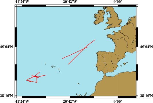
Seegebiet Sea Area |
| Multibeam Data, Binary | 15905 MByte | 5600 | |
| Datenformat Data Format |
Datenprozessierung Data Processing |
Schallgeschwindigkeitskorrektur Sound Velocity Correction |
|
| SIMRAD EM122 (ALL) | No tidal corrections. No filters are used. | For the transit towards the working area around the Oceanographer and Hayes Transform Faults no dedicated sound velocity profile has been used. Instead a profile from a previous cruise to the Atlantic Ocean has been used. In the working area a XBT sound velocity profile has been taken at the start of the survey. For the transit back the sound velocity profile from the survey area has been used. | |