Dataset SO272.202001.A
Date of Receipt
Data Type
Data Amount
Surveyed Kilometres
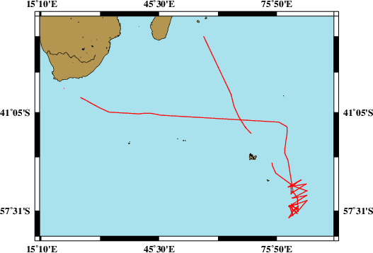
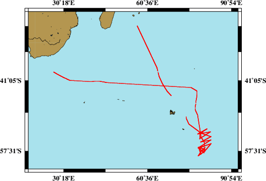
Sea Area
Data Format
Data Processing
Sound Velocity Correction
| Fahrtleiter Chief Scientist |
Dr. Gabriele Uenzelmann-Neben | ||||||
| Vermessungszeitraum Survey Period |
2020/01/11 - 2020/03/04 | ||||||
| Auslaufhafen Port of Departure |
Port Louis / Mauritius | ||||||
| Einlaufhafen Port of Arrival |
Cape Town / South Africa | ||||||
| Institution | AWI | ||||||
| Positionierungssystem Positioning System |
|
||||||
| Horizontales Datum Horizontal Datum |
WGS 84 | ||||||
| Tiefenbestimmungssystem Bathymetric System |
SIMRAD EM122 | ||||||
| Vertikales Datum Vertical Datum |
Sea Level. | ||||||
| Datendistribution Dataset Distribution |
|
||||||
| Zitat Citation |
Bathymetriedaten der Reise SO272 des Forschungsschiffes Sonne. Herausgeber: Alfred-Wegener-Institut | Helmholtz-Zentrum für Polar- und Meeresforschung, Bremerhaven 2020 |
||||||
| DOD-Referenz DOD-Reference |
20200003 |
| Datensatz SO272.202001.A Dataset SO272.202001.A |
Eingangsdatum: 2020/05/13 Date of Receipt |
||
|---|---|---|---|
| Datenart Data Type |
Datenmenge Data Amount |
Lotungskilometer Surveyed Kilometres |
Seegebiet Sea Area |
| Multibeam Data, Binary | 64425 MByte | 13500 | |
| Datenformat Data Format |
Datenprozessierung Data Processing |
Schallgeschwindigkeitskorrektur Sound Velocity Correction |
|
| SIMRAD EM122 (ALL & WCD) | Online software Kongsberg SIS. | Valeport SV-Profiler "MIDAS" and World Ocean Atlas 2013 with Software Sound Speed Manager. | |
| Datensatz SO272.202001.C Dataset SO272.202001.C |
Eingangsdatum: 2020/06/16 Date of Receipt |
||
|---|---|---|---|
| Datenart Data Type |
Datenmenge Data Amount |
Lotungskilometer Surveyed Kilometres |
Seegebiet Sea Area |
| Sediment Acoustic Data, Binary | 117406 MByte (ASD.ACF-PHF) 117499 MByte (ASD.ACF-SLF) 64352 MByte (PS3-PHF) 36743 MByte (PS3-SLF) 1795 MByte (SEGY-SLF) |
- |  |
| Datenformat Data Format |
Datenprozessierung Data Processing |
Schallgeschwindigkeitskorrektur Sound Velocity Correction |
|
| ATLAS PARASOUND (ASD.ACF & PS3& SEG-Y) | No information. | No information. | |