| Plattform Platform |
Reise-Nr. Cruise-No. |
Zeitraum Period |
Projekt Project |
Arbeitsgebiet Working area |
|---|---|---|---|---|
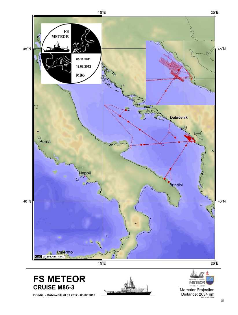
| Meteor | M86-3 | 20.01.2012 - 04.02.2012 | ALPHA |
Adriatic Sea |
| Fahrtleiter Chief Scientist | Institut Institute | Auslaufhafen Port of departure | Einlaufhafen Port of return | Stationskarte Station map | Schiffsroute Trackchart |
|---|---|---|---|---|---|
| Kopp Heidrun | Helmholtz Centre for Ocean Research Kiel (GEOMAR) | Brindisi | Dubrovnik | Karte Map |
Ziel der Reise / Objectives of Cruise:
Geophysical Investigations of the Adriatic Lithosphere Data acquisition: OBH/S seismics, MCS, multibeam, Parasound
Messungen / Measurements
| Institut Institute |
Wissenschaftler Scientist |
Anzahl Number |
Einheit Unit |
Typ der Messungen Type of measurements |
Kommentar Comments |
Daten im DOD Data in DOD |
|---|---|---|---|---|---|---|
| GEOMAH | Kopp Heidrun | 1439 | n miles | G74 Multi-beam echosounding |
Profiles and Grids (BATHXY) | no |
| GEOMAH | Kopp Heidrun | 342 | n miles | G76 Multichannel seismic reflection |
Profiles | no |
| GEOMAH | Kopp Heidrun | 1 | km | G90 Other geological or geophysical measurements |
Multibeam EM 122, EM 710 | yes |
| GEOMAH | Kopp Heidrun | 1 | stations | H00 Stations |
- | yes |
| GEOMAH | Kopp Heidrun | 1 | n miles | H80 Other physical measurements |
Underway measurements during the whole trip such as coordinates, depth, meteorological parameter and so on | yes |
Verankerungen / Moorings
| Institut Institute |
Wissenschaftler Scientist |
Typ der Messungen Type of measurements |
Kommentar Comments |
geogr.Breite Latitude |
geogr.Länge Longitude |
Daten im DOD Data in DOD |
|---|---|---|---|---|---|---|
| GEOMAH | Kopp Heidrun | G26 | 2 OBH/S positions Profile 04 | 42° 15.0' N | 18° 49.0' E | - |
| GEOMAH | Kopp Heidrun | G26 | 36 OBH/OBS positions Profile 01 | 43° 6.0' N | 15° 18.0' E | - |
| GEOMAH | Kopp Heidrun | G26 | 36 OBH/S positions Profile 03 | 42° 0.0' N | 19° 2.0' E | - |
| GEOMAH | Kopp Heidrun | G26 | 37 OBH/S positions Profile 02 | 41° 0.0' N | 18° 0.0' E | - |